Criss-Cross Brown Sugar Cookies | |
 I woke up one Saturday morning when I was five or six and decided to bake Criss-Cross Brown Sugar cookies for our neighbor Mrs. King. She’d always been so good to me, and I wanted to give her something. I often spent bread-baking days with her in her kitchen. She’d always make me a small loaf with whole wheat flour since my parents didn’t allow me to eat white bread. She’d play the piano for me while the bread baked, and she’d teach me a note or two of the sheet music. And she always invited me to go to church with her on Sundays.
Mrs. King lived about a half-mile back from our cottage in Hondo Canyon. The road to her house was called “King’s Road,” even though it ran along the edge of our property, which ended at her bridge. She had an easement to travel the road, as it was the only way in or out of the box canyon. (Today, hikers who park on Old Canyon Road just past Topanga Christian Fellowship church skirt around lower Hondo Canyon on their way up to the Backbone Trail.) |
I loved to get up early and bake. It made our little kitchen warm and made our whole cottage smell good. I was good at measuring and able to read recipes. And I loved putting the little criss-cross on the cookies with a fork while they were still warm. As the cookies cooled, I set them on wax paper and a plate. Then I had Mom call Mrs. King and tell her I was on the way.
Off I went down the back path to King’s Road, carefully balancing the plate with both hands. On the way, I tripped over a dip in the road. All the cookies slipped off the plate onto the ground. I was mortified—how could I arrive at Mrs. King’s without a gift?
I turned around and ran home.
•••
Other neighbors crossed our land, on foot and horseback. A small riding trail crossed our meadow and led to Old Solomon’s Road, a dirt track that ran parallel to Old Canyon all the way to the church. There weren’t any easements or fences at the time, and that was just fine with my parents and Mr. Solomon.
As my father put a roof on the cabin and further developed our property in Hondo Canyon, fewer picnics took place on the forty acres we owned at the top of Red Rock Road. Once in a while, I’d hike up with a friend or two to share the beauty. Mr. Stunt had given my father a handshake easement to cross his property, so I was never concerned about trespassing. Private property ownership had been established in the Canyon, but good will and good neighbors governed. We all felt a strong sense of personal responsibility to the land, the natural world, and its preservation.
By the time I left home in 1965, my father’s dream of building a home at the top of Red Rock had died away. He was too busy with the home in Hondo Canyon, four teenage daughters, and the family business.
And then, in the early 1970s, the State of California came knocking at the door of our family cabin. I’d just returned home with my two young children to discover that the government wanted Hondo Canyon—all of it—to provide the gateway to a future state park. They couldn’t figure out any access to the mountains and meadows above Old Canyon other than our property and the Kings’, which was now owned by Mrs. King’s son, Orson, and her grandchildren.
The State wanted to claim it all for a thoroughfare, possibly a highway, and even considered making Hondo Canyon a landfill dump. They threatened to take it by eminent domain. I had already been hearing that families were losing their ranches to public use. Paul Bragg, who owned the 80 acres between our cottage and the Topanga Meadows—including Mr. Post’s cabin—tried to hold out. But he was told he could either sell or be thrown out. The State had that power.
  |  The King family warded off the government by giving them the land in upper Hondo Canyon piecemeal. After long, pressured negotiations, their 80-acre parcel was reduced to the 12 acres that held their family homes. But our land in lower Hondo Canyon seemed temporarily safe, as the State turned its eyes toward Red Rock. The problem there was access. Property owners along Red Rock Road resisted granting easements across their private land. To appease their outrage, the government promised to build a parking lot on the Stunt Road side of the park, allowing visitors to reach the park from the firebreak road, known today as Calabasas Parkway.
Meanwhile, in 1980, Red Rock Canyon’s Boy Scout camp closed. The State took over that property under the auspices of the recently formed Santa Monica Mountains Conservancy, and Red Rock Park at last had an entrance. The promised parking lot off Stunt Road never happened. (To this day, most car access to the park goes through Red Rock Road, and visitors have the mistaken impression that once they have turned onto Red Rock Road, they are within the park boundaries.)
In 1980, I was busy building my career as a psychologist and raising my two daughters. After the government backed away from taking our Hondo Canyon property, I didn’t have much time to think about park land. The Topanga Association for a Scenic Community (TASC) had been formed and its members were doing a great job of warding off developers. (The developers included the daughter of Walt Disney, who wanted to build a golf course and homes in Summit Valley just off Highway 27. What is now Edelman Park preserves the natural heritage of that valley and protects indigenous peoples’ cave paintings.)
Eventually, I started to think about building up on the forty acres. There were several owners of forty-acre parcels at the top of Red Rock, most of whom had owned their property for a half-century and now wanted to build. I had my father design and render a house for me. It would take time and money to make it happen, but the surrounding area now had access to electricity and water.
Slowly but surely, however, the Conservancy claimed everything around those parcels. We were landlocked, and when we complained, the State taunted us: “Well, sue us then.” Our choice, and the choice facing the other landowners, was to sell it to the State or lose it to eminent domain. | Finally, in the 1990s, while I was busy earning my doctorate, Father told me he and Mom had decided to sell. They were growing older, and I had established my home just up the road from them.
The forty acres had a market value of $600,000. But how do you sell a landlocked parcel? The State paid $100,000, which my parents split with my aunt and uncle.
We’d been defeated. Yet, for the first time in my parents’ life, they had a savings account. Now they could live out their years in their beloved Hondo Canyon cottage.
For me, it wasn’t so simple. Like the plate of fallen cookies, I took the loss of that forty acres hard. The land was, in many ways, a sacred part of my heart and soul. It represented not only my happy childhood in Topanga Canyon, but my whole family’s history in this beautiful and unique place. Land was, and always had been, our wealth, our safety, and our security from a busy and fast-growing City of Angels. My dream of living at the top of the mountain, like my father’s, had died.
I now also understand the great ironies at play. In the effort to preserve land for public use, the State had disrespected private stewardship. Most people don’t realize that Musch Trail in Topanga State Park just off Entrada, is named for the Musch family, who did not want to sell their ranch but had it taken from them by the State. The same land America had swiftly taken from Mexican families and their Spanish land grants. The same land from which “Californios” had displaced Chumash and Tongva families, who’d been living on it and caring for it for thousands of years.
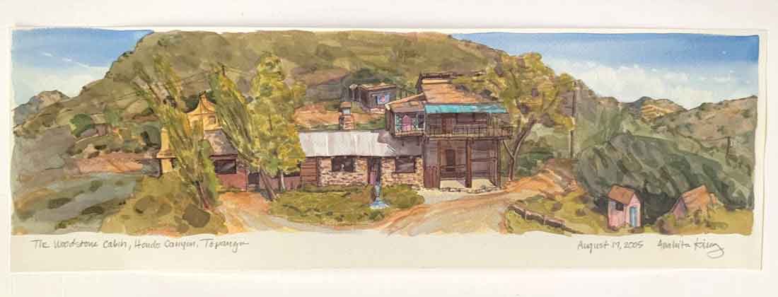
For further information about this series of events, see The Topanga Story, published by the Topanga Historical Society. (Topangahistoricalsociety.org)  Cy and Vera Wood in their later years, still spry and vital members of the close Topanga community they helped establish. They sold the Red Rock property in the 1990s, gave half to Karen’s aunt and uncle and had a tidy nest egg for their retirement. |  Above: The Woodstone Cabin, Hondo Canyon, drawing by Anahita King. 08.17.2005
Left: cabin looking up into Hondo Canyon, ridgeline barely visible | | | | | | | | | | | |
|
|
|
|
|